A Top-Drawer Tour of Tunbridge Wells, Replete with Rocks
37 people attending
3 places left
Wellington, Toad, High, Harrison's and Eridge. And among them, the Dog's Head, the Bishop's Head, the Ship, the Little Toad, the Loaf, the Parson's Nose, the Elephant, the Lion and the Bell. We'll have fun spotting the lapidary lookalikes while visiting every last characterful crag around Tunbridge Wells that I've noticed on the Ordnance Survey map. We'll take in views of the High Weald AONB and handsome Groombridge Place and walk through The Pantiles (a 17th-century colonnade) and alongside the preserved Spa Valley Railway. The walk will be rather long, but so are the days in May, and all this Georgian gentility and geological grittiness is just a 55-minute train ride from Charing Cross.
The sights:
Royal Tunbridge Wells: Not much building was done until the 1680s when the Church of King Charles the Martyr was built and the town began to develop around it, including beside the 160-metre Pantiles promenade. In 1750, sea-bathing became more popular than visiting spas, and so fewer visitors came to the town. However, with the advent of turnpike roads in the 1780s, the town's growth resumed, as did its patronage by the fashionable, and visits by figures such as lexicographer Samuel Johnson and the actor David Garrick gave it cachet. In 1735 Richard (Beau) Nash appointed himself as master of ceremonies for all entertainments, and under his patronage the town reached the height of its popularity as a resort. It remained some popularity in Victorian times and in 1909 Edward VII granted it the prefix 'Royal' to commemorate its use by his family.
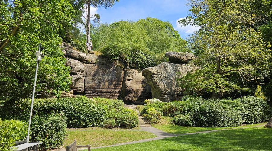
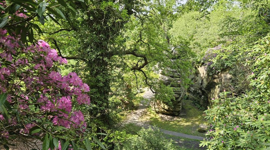
Rock outcrops - formation: We associate tors, isolated outcrops of rock, with Dartmoor and the Cairngorms, but the groups of rocks on the walk (Wellington, Toad, High, Harrison's and Eridge) are also tors. 'Tor' comes from the Welsh 'twr' meaning heap, but geomorphologists also know them as Castle koppies or kopjes. These tors have formed in sandstone from the Cretaceous Period, 135 million years ago (it is a greensand named the Ardingly Formation). Tors form when the overlying rock is eroded away and the underlying rock, now exposed and with the pressure above released, develops horizontal gaps called joints, which weathering then exploits, further breaking them into blocks. The weathered fragments were removed by soil processes in the periglacial (tundra-like) conditions that existed 10,000 years ago.
Rock outcrops - ecology: The Sussex Wildlife Trust reports of Eridge Rocks: 'It comes as a surprise to many that there are substantial cliffs tucked away in the woodlands of the High Weald of East Sussex. Giant boulders some ten metres high greet the visitor to Eridge Rocks. These rocks are designated a Site of Special Scientific Interest due to the community of plants growing on them...Explore a little further and you will find that this stony projection extends for some 600 metres, its shady nooks, deep fissures, and giant bastions are topped with ancient and gnarled beech, yew and holly.' Read this for more information.
Rock outcrops - miscellaneous: The tors are all free to visit, except for the best which is High Rocks. A £6 fee gives admittance to them, which are set in a Victorian arboretum and are linked by bridges and walkways (although it may be closed if a function is on). Read up here. If you don't want to pay to enter, you can spend 40 minutes in the pub/café on the site instead. Two rock outcrops were used for filming Doctor Who serials in the classic era: Harrison's Rocks in Castrovalva in 1981 (watch the clip here) and High Rocks in The Mind Robber in 1968 (watch the clip here) .
Spa Valley Railway: Wikipedia writes: A standard gauge heritage railway...that runs from Tunbridge Wells West railway station...to High Rocks, Groombridge, and Eridge, where it links with the Oxted Line. It crosses the Kent and East Sussex border, covering a distance of 5 miles (8 km). We won't be riding on this railway, but our walk is partly alongside its tracks.
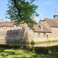
Groombridge: A small village with Old Groombridge in Kent and New Groombridge in East Sussex. We'll just see New Groombridge, but we'll get good views of Groombridge Place in Old, a moated manor house started in 1293. Its historical connections are manifold. Owner Richard Waller, fell in love there with Cicely Neville who was known for her beauty. She was the wife of Richard of York and mother of Richard III. It later belonged to English barrister and architect Philip Packer, who, in 1662, built the present-day house with the help of his friend Christopher Wren. The diarist John Evelyn helped lay out the formal gardens. The house has been used as a location for filming including: Pride and Prejudice (2005); The Draughtsman's Contract (1982) and The Day of the Triffids (2009). The Heir, a novel by Vita Sackville-West, was inspired by the house. It was the model for Birlstone Manor in Sir Arthur Conan Doyle's Valley of Fear. Conan Doyle was a frequent visitor.
Frant: A pretty place 180m up (the highest point on the walk). St Alban's Church is regency, 1819-1822, replacing an C11 structure. The architect, John Montier, was ahead of his time in applying the syntax of Gothic architecture correctly, well before the Gothic Revival. Substantial stone cottages around the spacious green along with Edwardian and Victorian villas.
The route:
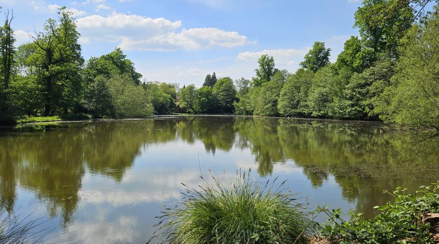
Full version: 25 km (15.5 miles); 468 m of ascent. We'll head south through the town down The Pantiles, then head north and west through Tunbridge Wells Common to see Wellington Rocks and Rusthall Common to see The Toad. We'll then then head south down Tea Garden Lane to High Rocks for a tea break. From then on, we'll use the Tunbridge Wells Circular Walk through Groombridge to Harrison's Rocks, then to Eridge Rocks where we'll have lunch and follow the High Weald Landcsape Trail to Eridge Green. An ascent to Frant will lead to a descent back to the town, which we'll enter from the southeast through the Banner Farm and Mount Sion areas, along Farmcombe Road and Grove Hill Road.
Shortened version: 15 km (9.5 miles); 265 m of ascent; includes all the rocks. As before, but at the village of Eridge Green you can catch a half-hourly, 15-minute bus service back to Tunbridge Wells.
Dogs:
I love having dogs on my walks and this walk is somewhat suitable for them. It will be long and will potentially happen in warm weather, although much of the route will be shady. There may be some livestock. A dog off the lead must be obedient.
IMPORTANT! - Participation Statement
You MUST complete a Participation Statement, here, in addition to booking your event space before attending an OutdoorLads event. You only need to complete this Participation Statement once, not for each event you attend.
(Images taken by the leader and OutdoorLads member Alex Young on their recce in May 2024.)


What to bring
Sturdy walking boots are essential as the walk will involve rough terrain and a few steep ascents and descents. Wear thick socks to prevent blisters. Otherwise, just bring and wear clothing appropriate to the weather. Jeans should be avoided, though, because they become heavy, cold and chafing if wet.
Food & drink
Please bring a packed lunch and plenty to drink. We will have a pub/café stop in the morning at High Rocks and a late lunch, plus there are pubs on the town at the end.