Isle of Wight Double, Day 2: Alum Bay to Brighstone
31 people attending
9 places left
Introduction:
Last year it was a Dorset Double. This year it's an all-new Isle of Wight Double, taking place on the Saturday and Sunday of the late-May Bank Holiday weekend. Campsites and B&Bs seem to be in rather short supply (and expensive as the late May Bank Holiday weekend is at the start of the half-term holiday) so you are advised to book right now. I'll lead one walk, assisted by lovely local lad Lee Pringle, and he will lead the other, assisted by me. Demand may be reduced as Big Spring Camp will be running at the same time, but even so, I hope you can come and experience an 'overseas' trip to the Isle of Wight and its Area of Outstanding Natural Beauty, where the superb coastal scenery is matched by the downland scenery, and dense forests meet quaint villages.
Schedule:
- Day 1 (Saturday 25 May): Niton to St Catherine's Down and Point, Blackgang, Chale, Shorwell and Brighstone - linear walk with bus from Brighstone to the starting point at Niton.
- Day 2 (Sunday 26 May): Alum Bay and The Needles to Freshwater, Mottistone and Brighstone - linear walk with bus from Brighstone to the starting point at Alum Bay.
Day 2: Alum Bay and The Needles to Freshwater, Mottistone and Brighstone
Both these walks explore the most undeveloped part of the island, the southwest coast, which is also called the 'Back of the Wight'. Here, our second island getaway daywalk will comprise the pretty villages of Brighstone and Mottistone, the broad sandy bays of Brook, Compton, Freshwater and Alum, the downland at Mottistone and Freshwater, and the rocks of Hanover Point Ledges, Freshwater Bay and the Needles. Breathtaking views will abound: across the island, across the Channel, and across The Solent. In order to attain such views, there will be some climbing, but at only 20 km (13 miles), the walk won't be a killer, and there will be enough cafes to keep us happy and hydrated.
The sights:
Brighstone: Despite C20 development, still picturesque with cottages and villas built in a variety of local building stone which includes sandstone and chalk, and many with thatched roofs. St Mary's Church was heavily restored in 1852 but is from the C13. The battlemented tower is C14 and C15. The Old Rectory is Georgian. Bishop Samuel Wilberforce (nicknamed 'Soapy Sam' and notorious for his opposition to Darwin's On the Origin of Species in a debate in 1860) became rector in 1830, and would entertain his father, anti-slavery campaigner William Wilberforce, in the Rectory.
Mottistone: 'Mottistone is a set piece with its sloping village green, the church on a hillock to the west. and to the north, the long, low, L-shaped Manor backed by a a wooded hill-fold rising a little higher' (The Buildings of England: The Isle of Wight). St Peter and St Paul's Church is C12 but much of the current building is C15. National Trust-owned Mottistone Manor is C15 and C16. The whole house was remodelled in the 1920s by the architects Seely & Paget (John Seely was Lord Mottistone). The gardens are open to the public, and are the southernmost and driest garden owned by the NT. The Island's only megalithic monument, the Longstone is nearby. 'Mottistone' derives from the Longstone, used as a meeting place (or 'moot-stone') in Saxon times. The Longstone consists of two pieces of local greensand sandstone, the larger stands at 3.9 metres and the smaller lies at its foot. They are likely Neolithic, 4100 to 2500 BCE.
Freshwater: A scattered village which enjoyed some popularity as a Victorian seaside resort (The Albion Hotel is typical) and attracted residents such as the poet Alfred Lord Tennyson and the photographer Julia Margaret Cameron. Overlooking Freshwater Bay is Fort Redoubt, built in 1855 to guard against a French invasion.
Freshwater Bay: Famous for its geology and rock formations. The bedding planes of the chalk are noticeable, with each one delineated by bands of flint. Arch Rock collapsed in 1992. Stag Rock is so named because a stag leaped on to the rock from the cliff to escape during a hunt. Mermaid Rock became detached from the cliff face in 1968.
Tennyson Down: A grassy ridge of chalk rising to 147m above sea level. Named after Lord Tennyson who lived at nearby Farringford House for nearly 40 years. The poet used to walk on the down almost every day. The monument, a Cornish granite Celtic cross, is by JL Pearson, and dates from 1897, five years after Tennsyon's death.
The Needles: A row of three chalk sea stacks rising 30m out of the sea. The 35m Needles Lighthouse was built in 1859. The adjacent waters and seabed form part of The Needles Marine Conservation Zone. The formation takes its name from a needle-shaped pillar called Lot's Wife which collapsed in 1764. The remaining rocks are not needle-like, but the name has stuck. The Needles were considered by the BBC's Seven Natural Wonders one of the wonders of Southern England.
The Needles Batteries and Rocket-Testing Facility: Two heavy gun emplacements built above The Needles to guard The Solent. Old Battery was built in 1861-2, New in 1895 when the Old Battery's cliffs crumbled. In the 1950s the battery was used for testing the Blue Streak missile, as well as the Black Knight and Black Arrow satellite launch vehicles. The rocket testing facilities are a scheduled monument.
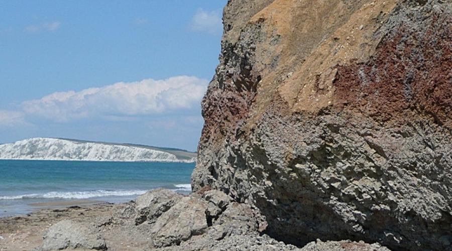
Alum Bay: A classic sequence of upper Paleocene and Eocene (65-44 mya) beds of soft sands and clays, up against the Cretaceous chalk (100-65 mya). The formation would have been the UK's example of the famous K-T boundary that represented and evidenced the end of the dinosaurs and the Mesozoic Era, but the crucial layer containing the iridium from the asteroid impact in Yucatan, Mexico, was eroded away prior to further sedimentation. The sands are coloured by oxidised iron compounds. On the clifftop there is an amusement park and a chair lift takes tourists to and from the beach below. Alternatively, a footpath leads to the beach via Alum Bay Chine (we could take either, time permitting). A traditional souvenir of Alum Bay were ornaments containing layers of the coloured sands. In the past visitors could dig out the sand themselves but the removal of sand is now prohibited.
The route (click the link in red to see it):
The route as described will be reversed and the coastal path at Compton Bay will be omitted due to landslips. Heading west out of Brighstone, Hoxall Lane will take us to Mottistone where we'll ascend Mottistone Common and Mottistone Down where we'll join the Worsley Trail heading west. The Hamstead Trail will take us south to Brook where we'll join the coastal path along Brook and Compton Bay to Freshwater. At Freshwater Bay we'll ascend the hill, following the Tennyson Trail west to the cliffs above The Needles. Then, turning east and then north we'll head along the coastal path to Alum Chine (time and stamina may allow a descent to the beach at Alum Bay, or you can use the chairlift). We'll then get the bus back to Brighstone.
Transport back:
Southern Vectis run bus services that are frequent and extensive. We will catch the No. 12 bus back from Alum Bay to the starting point after you've spent as much time as you want there.
Accommodation:
Book for at least Friday 24 May to Sunday 26 May (3 nights). The following day is Bank Holiday Monday. You are advised to book now.
- Campsites: Choose one near Brighstone. The best option is Grange Farm, followed by Brighstone Holiday Centre. Other campsites for members of the Camping and Caravanning Club (further away) are: Thorncross Farm, Meadow Lakes and Chine Farm.
- Bed and Breakfasts: Choose one in or within a couple of miles of Brighstone. Search Booking.com here. YHA Brighstone has closed.
Dogs:
I love having dogs on my walks and this one may be suitable for dogs with lots of stamina. It is long, has some fields with livestock and will partly be along lanes. Much of the route is exposed to the sun so a dog may overheat, although they will be able to go in the sea at Hanover Point. Your dog must be responsive if it is off the lead.
IMPORTANT! – Participation Statement:
You MUST complete a Participation Statement, in addition to booking your event space before attending an OutdoorLads event. You only need to complete this Participation Statement once, not for each event you attend.
(Photo credits: Alum Bay and the white cliffs of West High Down: Photo © Chris Gunns (cc-by-sa/2.0); Exposed tilted bed on the beach near Hanover Point: Photo © Jim Champion (cc-by-sa/2.0); Brighstone: Photo © Stephen McKay (cc-by-sa/2.0); Mottistone church: Photo © Philip Halling (cc-by-sa/2.0); Above Mottistone: Photo © Ian Capper (cc-by-sa/2.0); The Longstone: Photo © Ian Capper (cc-by-sa/2.0); Near Hanover Point: Photo © Graham Horn (cc-by-sa/2.0)The Needles, Isle of Wight; Photo © Christine Matthews (cc-by-sa/2.0); Freshwater Bay, Stag Rock and Mermaid Rock: Photo © Chris Gunns (cc-by-sa/2.0); Tennyson Monument, Totland, Isle of Wight: Photo © Peter Trimming (cc-by-sa/2.0); High Down: Photo © Anne Burgess (cc-by-sa/2.0); Alum Bay, Isle of Wight: Photo © Christine Matthews (cc-by-sa/2.0); Photo of The Needles by Mypix, licensed under CC BY-SA4.0. All pictures are copyrighted but are licensed for reuse under Creative Commons CC-BY-SA 2.0 and are here attributed to their copyright holders.)


What to bring
Walking boots and thick socks are essential to cope with the uneven, hilly terrain. Bring or wear clothes and equipment suited to the weather, including a raincoat if rain is forecast, and a hat and high-factor suncream if sun is. Once on the cliffs the walk will offer little respite from any strong sunshine.
Food & drink
Please bring a packed lunch and lots to drink, although there should be a chance to buy them in Brighstone before the walk. We will have lunch at Freshwater. There will be opportunities to get drinks and ice creams at cafes at The Needles and Alum Bay, but no opportunities to get drinks after Freshwater, so make sure you top up with water beforehand.