Forts, Forests and our Naval Force at Anchor
38 people attending
0 places left
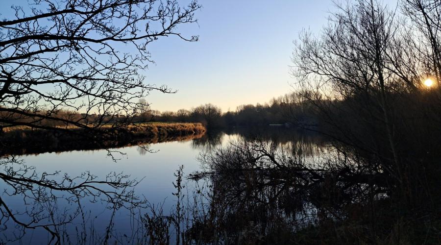
Portsmouth is Britain's most densely populated area, perhaps because it is trapped on its island and can't sprawl for miles over the countryside. Mainland Portsmouth does exist, but the spread of houses is kept in check by the wall of chalk that is Portsdown Hill. In the morning we'll walk along the hill's crest, follow the chain of Victorian forts that were built to defend the harbour, and admire the view of Portsea Island, Portsmouth Harbour, the Solent and the Isle of Wight. In the afternoon we'll descend for a pub lunch at the village of Southwick, a settlement so shielded from the late twentieth and early twenty-first centuries, that it comes as a surprise that Portsmouth is so close.
The sights:
Portsdown Hill: A long chalk ridge that reaches only 131m above sea level but offers superb views to the south over Portsmouth, the Solent, Hayling Island and Gosport, with the Isle of Wight beyond. To the north lies the Forest of Bere (a vestigial royal forest), with the South Downs visible in the distance. The chalk downland is an SSSI and lining the top are Victorian forts and active military research establishments, including one of the core sites of DSTL (Defence Science and Technology Laboratory) and QinetiQ.
Portsdown Hill Forts: An 1859 Royal Commission concluded that Portsmouth was vulnerable to an enemy attack from inland (new rifled gun barrels enabled an invading army to land elsewhere, circle around to the top of the hill and bombard the city from there). As a result, six forts were built along the ridge between 1860 and 1871. But the threat from Napoleon III of France failed to materialise and they were nicknamed 'Palmerston's Follies'. They did find use as anti-aircraft gun emplacements in World War II. We'll see Fort Widley, Fort Southwick and Fort Nelson.
Fort Nelson: Completed in 1871, grade I-listed. Run as a museum of artillery since 1994 by the Royal Armouries. A fantastic free museum which you can visit on a different occasion. Exhibits include C15 bombards and a huge C15 Turkish cannon, French field guns captured at Waterloo, parts of the Iraqi supergun and two of Mallet's Mortars (1850s), one of which is visible from outside. These had the biggest bore of any gun ever. Alongside the Mallet's Mortar is a gun from a George V-class battleship (1939) capable of firing a shell 47 km (28 miles).
Nelson Monument: The fort is named after the Nelson Monument which stands adjacent. 37 m tall on a granite base and overlooking Portsmouth Harbour. Completed in 1807, two years after the Battle of Trafalgar, by John Thomas Groves. Modelled on the Aksum (Axum) Stele in Ethiopia. It was paid for out of two days' pay from all the survivors of Trafalgar and a public prize fund.
Southwick: A pretty village quite isolated from the Solent's urban sprawl despite being very close to it. The site of Southwick Priory (C12), a few walls of which can be seen. Still entirely owned by the Southwick Estate, so all the houses have dark red-painted front doors. Only the White House, the vicarage, and Church Lodge are exceptions. St James' Church is Grade I-listed. An immaculate building, largely rebuilt in 1566, but in Georgian times was given a west gallery with barley twist wooden columns, upholstered box pews, three decker pulpit and reredos with Baroque painting.
Southwick's D-Day Connections: Southwick House (1813, rebuilt 1841) was requisitioned in World War II to be Dwight Eisenhower's headquarters for Operation Overlord (the D-Day landings). The Golden Lion pub became an unofficial officers' mess with the lounge bar used by Eisenhower, other American generals, Montgomery, Prince Philip, Earl Mountbatten and Jan Smuts. Sadly the Golden Lion is a bit pricey, so we're booked in at The Red Lion, also in the village.
The route (car users click here; train users click here (the route is the the same except for the extension from and to Cosham Station for train users)):
Those using the train will walk up Cosham High Street, cross the A3 and use the B2177 to ascend Portsdown Hill to meet those who came by car beside Fort Widley. We'll all then walk west along Portsdown Hill as far as Fort Nelson using its grassy areas, pavements and roadside verges. At Monument Lane will descend north to Boarhunt. At Ashley Down Farm, we'll use a footpath to go to Southwick, crossing over the B2177. We'll walk north along Fareham Road, then east along West Street and go to the pub on the High Street. After lunch, we'll walk along the High Street then pick up the Pilgrim's Trail to go to Pitymoor Lane. A footpath heading east through Sawyer's Wood will take us to Pigeon House Lane and another footpath will take us to Potwell Farm and Mill Lane. We'll ascend to go back to the car park beside Fort Widley. Those who took the train will then retrace their steps to go back to Cosham.
Dogs:
I love having dogs on my walks and this one is suitable for them as it is short and has few fields with livestock. Some of the route is along lanes so dogs may need to go on leads. Your dog must be responsive if it is off the lead.
IMPORTANT! – Participation Statement:
You MUST complete a Participation Statement, in addition to booking your event space before attending an OutdoorLads event. You only need to complete this Participation Statement once, not for each event you attend.
Anyone with COVID-19 symptoms, even if they are extremely mild, or who has recently tested positive for Covid-19, is asked not to attend.
(Images: Fort Widley from North, with Portsmouth, Isle of Wight, and Solent: Photo © Hunanuk (cc-by-sa/4.0); Portsmouth from Portsdown Hill: Photo © Marathon (cc-by-sa/2.0). These images are copyrighted but are here credited to their copyright holders and are licensed for reuse under Creative Commons CC-BY-SA/2.0 or Creative Commons CC-BY-SA/4.0. All the other images were taken by the leader in December 2022.)
What to bring
Walking boots and thick socks are essential to support the ankles, give traction and keep the feet dry. If mud is severe then gaiters are useful, and if the weather is wet, a waterproof coat and trousers. Consider layering for cold conditions: base layer, fleece (or two), insulated coat. Gloves and hats are also advised.
Food & drink
We are booked to have a pub lunch at The Red Lion in Southwick at 13:30. I'll send the menu out two weeks before the walk for you to choose to get the pre-order ready. If you want to bring a packed lunch, that's fine. The church has benches you can sit on.
The menu is:
Starters (to have as a main course):
- Soup of the Day £6.75: Homemade soup with a crusty bread roll, salted butter (V)
- Breaded Calamari £7.50: Panko breaded calamari accompanied with dressed leaves and sweet chilli sauce
- Duck Liver Pate £7.50 Duck liver pate with homemade fig chutney, served with toasted malted brown bread
- Char-Sui Pork £7.50 Char-Sui marinated pork skewers with bbq dip (GF)
- Halloumi Fries £7.50 Zatar crusted halloumi fries with chilli jam (GF V)
- Pork Sausage Roll £6.95
- Homemade Parmesan and smoked cheddar sausage roll served with onion jam Chips (VE) £3.50
Sandwiches and warm ciabattas: Either served on toasted malted brown bread or warm ciabatta (PLEASE SPECIFY). Served with coleslaw and fries.
- Bacon & Brie £8.95 Smoked Bacon with French brie
- Roast Beef & Horseradish £8.95 Rare roast beef with salad and horseradish mayonnaise
- Prawn Marie Rose £9.75 Cold water prawns, with a Marie Rose sauce
- Sausage & Onion £8.95 Pan cooked sausages topped with fried onions
For those with smaller appetites: (PLEASE SPECIFY otherwise I'll assume you'll want a full size version)
- King Prawn Rigatoni £10.25 King prawns cooked in a chilli & roasted tomato sauce with rigatoni and garlic bread
- Ham Egg & Chips £9.95 Home cooked honey and mustard glazed ham, with egg and chips. Served with either beans or peas (PLEASE SPECIFY) (GF)
- Sausage & Mash £9.95 Pan fried sausages with smoked cheddar mash and onion gravy with roasted carrots and cabbage
- Fish & Chips £10.50 Beer battered cod served with chips, tartare sauce and a choice of mushy or garden peas (PLEASE SPECIFY)
- Scampi £9.95 Wholetail breaded scampi with chips and a choice of mushy or garden peas (PLEASE SPECIFY) with tartare sauce
- Homemade Steak Chilli £9.95 Spicy steak and bean chilli served with rice, cheesy garlic bread and sour cream
Red Lion Favourites:
- Steak & Guinness Pie £15.95 Homemade steak & Guinness pie served with chips or mash, roasted carrots, tenderstem broccoli and gravy
- Ham Egg & Chips £14.75 Home cooked honey and mustard glazed ham, with eggs and chips. Served with either beans or peas (PLEASE SPECIFY) (GF)
- Sausage & Mash £14.75 Pan fried sausages with smoked cheddar mash and onion gravy with roasted carrots and cabbage
- Fish & Chips £15.25 Beer battered cod served with chips, tartare sauce and a choice of mushy or garden peas (PLEASE SPECIFY)
- Scampi £14.50 Wholetail breaded scampi with chips and a choice of mushy or garden peas (PLEASE SPECIFY) with tartare sauce
- 8oz Beef Burger Homemade burger served in a brioche bun, with chips, salad and gherkins: with smoked cheddar £14.75; with smoked cheddar & Stilton £14.95; with bbq pork and smoked cheddar £14.95 8oz (PLEASE SPECIFY)
Main courses:
- Sirloin Steak £21.50 Pan fried 8oz sirloin steak. Served with onion rings, roasted tomato, chips and a peppercorn sauce (GF)
- Homemade Steak Chilli £14.95 Homemade steak and bean spicy chilli. With rice, sour cream, cheddar and5wq cheesy garlic bread.
- Lamb & Mint Suet Pudding £16.50 Homemade braised lamb and mint steamed suet pudding. Served with garlic mash, roasted carrots, cabbage and a mint gravy.
- Breaded Stuffed Chicken £15.95 Panko breaded chicken supreme filled with truffled brie served with garlic and thyme gratin potato, tenderstem broccoli, roasted carrots and a peppercorn sauce (GF)
- Red Lion Ploughman’s £15.25 Home cooked ham, cheddar, Stilton with our homemade Parmesan and pork sausage roll, pickles, chutney and warm bread
- Homemade Vegan Balti £14.25 Roasted vegetable, sweet potato and chickpea Balti served with rice, a poppadom and mango chutney (GF, VE)
- Homemade Bean Burger £13.95 Falafel and roasted vegetable bean burger served in a toasted red onion bagel with chilli jam, salad and chips (VE)
- Butternut Squash Tortellini £14.75 Fresh tortellini filled with butternut and ricotta cooked in a Parmesan and sage cream sauce, served with garlic ciabatta (V)
- Roasted Salmon £15.25 Sweet chilli marinated salmon fillet served on a bed of spiced roasted vegetable and spinach rice (GF)
- King Prawn Rigatoni £15.25 King prawns cooked in a chilli & roasted tomato sauce with rigatoni and garlic bread
Sides:
- Cheesy Chips (V) £4.50
- Garlic Ciabatta (V) £3.50
- Cheesy Garlic Ciabatta (V) £4.50
- Gratin potato £4.00
- Side of Vegetables (GF VE) £3.25
- Onion Rings (V) £3.50
- Zatar Spiced Halloumi Fries (GF V) £5.25
- Crusty Bread Rolls & Butter (GF V) £2.50
- Gluten free bread rolls available at a £1.00 supplement.