The Ullswater (High) Way - Part 2 (North)
8 people attending
4 places left
The Ullswater Way is a 20-mile waymarked walking route that circumnavigates the entire shore of Ullswater. The route was launched in the wake of the devastating floods of Storm Desmond in 2015 which caused widespread flooding and destroyed the 300-year-old stone bridge in Pooley Bridge at the northern end of the lake. With the help of volunteers and the national park authority, the walking routes were fully connected to create a singular path attracting visitors back to the area to enjoy the stunning and varied landscape.
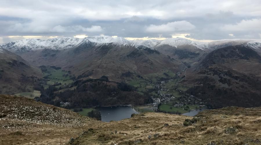
Many consider Ullswater to be the hidden gem of the Lake District and as the most beautiful of the English Lakes. It is pure and tranquil and relatively unspoilt by tourism and commercialism. Ullswater is the second largest lake in the Lake District, approximately 9 miles long, ¾ of a mile wide and nearly 200 feet deep. It was formed after the last ice age when a glacier scooped out the valley floor then filled with meltwater when the glacier retreated.
This walk is part of a series of four walks exploring The Ullswater Way, and the two "Loop" walks that were added later, over two weekends. Each weekend, we'll walk one side of the lake on the Saturday and do a shorter "Loop" walk on the Sunday. However, you don't have to do them all and are welcome to pick the ones you want to do. Please note, however, the Saturday walks will be mountain walks as the intention is to deviate from the main, waymarked route of The Ullswater Way in places and, depending on weather conditions, daylight and the group, take in one or more of the peaks which line the lake - these are up to 700m.
This third walk will cover the Northern lake shore from Glenridding to Pooley Bridge via Aira Force. However, we'll meet in Pooley Bridge and take advantage of the current subsidised £2 bus fares to travel to Glenridding on the 508 bus and walk back to Pooley Bridge. The waymarked route is 9.5 miles but if, as we intend, we take in some of the Wainwrights along the route - Glenridding Dodd (442m), Sheffiled Pike (676m) and Gowbarrow Fell (481m) - the walk could be considerably longer and with significant ascent. Given the time of year, please bring a head torch.
The other walks in the series can be found here:
Ullswater (High) Way - Part 1 (South)
All photos are leader's own.
IMPORTANT! - Participation Statement
You MUST complete a Participation Statement, in addition to booking your event space before attending an OutdoorLads event. You only need to complete this Participation Statement once, not for each event you attend.
Anyone with COVID-19 symptoms, even if they are extremely mild, or who has recently tested positive for Covid-19, is asked not to attend.


What to bring
Water: bring at least two litres in a water bottle, or better still, a hydration bladder
Medicines: if you have hay fever, diabetes, minor ailments etc.
Day Rucksack: typically 20-30 litres, they are comfortable to wear and allow you to use your arms freely
Waterproof bags: keep spare clothing, electronics and anything else dry even when your rucksack leaks by using Ziploc type food bags or, better still, outdoor activity waterproof bags
Boots: waterproof and breathable hiking boots with good ankle support
Gaiters: recommended for wet weather or boggy conditions
Socks: proper walking socks will keep your feet dry and help prevent blisters, and carry a spare, dry pair
Walking Poles: always optional, love them or hate them, but give them a try and decide for yourself
Layered clothing: lets you quickly adapt to changes in the weather and body temperature. Go for a base layer (vest or t-shirt) and a mid layer (a micro fleece or shirt) and in cooler weather add an outer layer (a windproof jacket or thick fleece)
Trousers: no jeans as they become heavy and cold in the rain, breathable fabrics are more comfortable and dry and on warm days shorts are OK
Waterproof jacket: essential when hiking in all but the calmest of weather, breathable fabrics are more comfortable and dry.
Gloves: Windproof, or better still, waterproof gloves are the best choice, bring a spare pair if expecting rain.
Hat or cap: stay warm in winter and shaded in summer
Sunglasses: for any sunny day, even in winter
Sun cream: can be useful even on cloudy and winter days
Snacks: bring biscuits, energy bars, gels, bananas, chocolate or dried fruit for example and put them somewhere easy to get hold of
Lunch: bring a packed lunch unless otherwise stated
Emergency equipment: the walk leader will bring any emergency equipment required for the group, but you are welcome to bring any that you have, such as additional high energy food, a survival bag, a whistle, a medical kit, a torch and something to make fire (either storm proof matches or a firelighter
Map and compass: the walk leader will have these, but if you like map reading or want to develop your skills, bring yours along
Mobile Phone: keep it in a waterproof bag for use in emergencies, and a spare battery/charger is a good idea
Food & drink
You will need to bring a packed lunch and plenty of water (at least 2 litres). There are limited facilities in Pooley Bridge, Glenridding and Patterdale.